Samuel Cachero´s path
Discover
Places of interest


Beschreibung
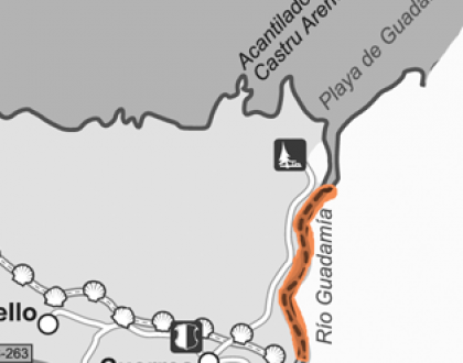
This 4 km long route starts at Cuerres village, so to get there you will have to drive along AS263 to the eastern limit of Ribadesella’s borough.
The starting point of your walk is the medieval stone bridge over the Guadamía stream, natural limit of Ribadesella’s municipality. From the bridge you’ll have to walk to the north, following down the course of water on your right. Soon you’ll find the canal of an old watermill, and the main structure of this ancient invention. Past this first mill, there is a succession of tiny footbridges that will make you cross several times to both sides of the stream. Next, you’ll get to the old Tosquila watermill, with a beautiful charming waterfall. There, you have to continue walking down the river without crossing to the opposite side. Once past a place called La Xatera, you’ll discover the sandy surface of the Guadamía beach, probably the coziest cove of the district.
To go back to Cuerres village, you can easily go over the trail you have left behind or, if you prefer, you can return to your starting point through Llames de Pría village. From Guadamía beach a signed coastal path to the east leads to Llames. Once in the village, a panel at La Bolera square describe the route back to Cuerres. You’ll have to walk to the south along the local road to Belmonte village. 800 m far you’ll get to a turning point on your right with a Way of Saint James’ sign. Heading this narrow road to the west you’ll get easily to the pilgrims’ bridge, the starting point of this route.
Easy level hiking path, from Cuerres village to Guadamía beach. Length: 4 km.
This 4 km long route starts at Cuerres village, so to get there you will have to drive along AS263 to the eastern limit of Ribadesella’s borough.
The starting point of your walk is the medieval stone bridge over the Guadamía stream, natural limit of Ribadesella’s municipality. From the bridge you’ll have to walk to the north, following down the course of water on your right. Soon you’ll find the canal of an old watermill, and the main structure of this ancient invention. Past this first mill, there is a succession of tiny footbridges that will make you cross several times to both sides of the stream. Next, you’ll get to the old Tosquila watermill, with a beautiful charming waterfall. There, you have to continue walking down the river without crossing to the opposite side. Once past a place called La Xatera, you’ll discover the sandy surface of the Guadamía beach, probably the coziest cove of the district.
To go back to Cuerres village, you can easily go over the trail you have left behind or, if you prefer, you can return to your starting point through Llames de Pría village. From Guadamía beach a signed coastal path to the east leads to Llames. Once in the village, a panel at La Bolera square describe the route back to Cuerres. You’ll have to walk to the south along the local road to Belmonte village. 800 m far you’ll get to a turning point on your right with a Way of Saint James’ sign. Heading this narrow road to the west you’ll get easily to the pilgrims’ bridge, the starting point of this route.

Kontakt


View map

Don't miss it
-
8.3 km
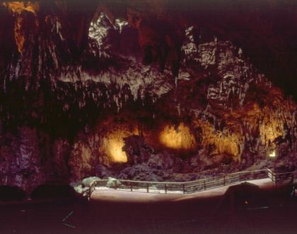 Spektakuläre Höhle, die von der UNESCO zum Weltkulturerbe erklärt wurde. Es handelt sich um eine prähistorische Höhle von großer Bedeutung mit einer bedeutenden archäologischen Stätte und